



Massive Storm System of March 2026: Tornadoes, Blizzards, Outages and Wildfires Across the U.S.
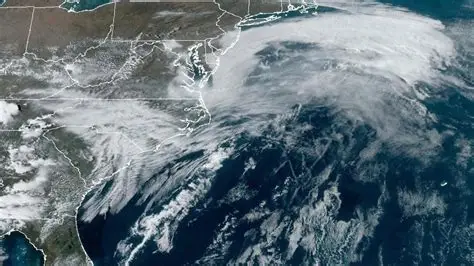
A massive storm system that swept across the United States from March 14 to March 16, 2026 produced an extraordinary mix of weather hazards, from blizzard conditions and historic snowfall in the Upper Midwest to damaging thunderstorms and tornadoes across the Southeast and Mid-Atlantic.
The same period also brought widespread power failures, major flight disruption, dangerous winds and a rapidly evolving wildfire emergency in Nebraska.
The event was notable not because every hazard came from one identical weather mechanism, but because multiple high-impact threats unfolded across the country at nearly the same time. The central low-pressure system drove the snow, ice, strong winds and severe thunderstorms across a huge swath of the United States. Farther west, extreme drought and high winds helped fuel major wildfires, while a separate burst of unusually early heat developed in the Southwest.
For millions of Americans, the massive storm system became a reminder of how quickly spring weather can swing between winter cold, violent thunderstorms and dangerous fire conditions.
What Happened During the March 2026 Storm?
The core of the massive storm system developed over the central Plains before strengthening rapidly and tracking toward the Great Lakes.
The National Weather Service later described the March 14-16 event as a powerful winter storm that produced widespread significant snowfall, followed by blizzard conditions as Arctic air wrapped around the strengthening low-pressure center.
As the low intensified, it pulled moisture northward and collided with colder air. The result was a broad zone of heavy snow across Minnesota, Wisconsin and Michigan, with sleet, freezing rain and powerful winds in some areas.
On the warmer side of the system, thunderstorms raced across the Southeast and Mid-Atlantic, where forecasters warned about damaging straight-line winds and tornadoes.
The massive storm system did not affect every state in the same way. Minnesota and Wisconsin faced deep snow and whiteouts, Michigan dealt with ice and utility damage, and the Carolinas and Mid-Atlantic faced severe thunderstorms and damaging winds.
Historic Snowfall Buried Parts of the Upper Midwest
Some of the most striking impacts came from Minnesota and Wisconsin.
The National Weather Service Twin Cities storm summary reported widespread snowfall totals of 10 to more than 20 inches, with isolated amounts reaching roughly 2 to 3 feet in parts of west-central Wisconsin, Michigan’s Upper Peninsula and northern Lower Michigan.
Minneapolis-St. Paul International Airport recorded 8.9 inches over the two-day period, making it the biggest storm of the 2025-26 winter season at the airport.
Farther east, northeast Wisconsin experienced even more extreme totals.
The National Weather Service Green Bay event review said Green Bay received 26.6 inches of snow, making the event the city’s second-largest snowstorm on record. Localized totals above 30 inches were reported from areas stretching from Wausau toward Marinette and Door County.
Snowfall rates in northeast Wisconsin reached up to 4 inches per hour at times, and thunder and lightning accompanied some snow and sleet.
The massive storm system combined deep accumulation, powerful winds and rapidly falling visibility, making travel dangerous or impossible.
Blizzard Conditions Turned Roads Into a Major Hazard
Heavy snow alone does not define a blizzard. Strong winds and severely reduced visibility are central to the danger, and the March event delivered both.
Across parts of Minnesota, Wisconsin and Iowa, wind gusts frequently reached the 40 to 55 mph range. In northeast Wisconsin, gusts climbed even higher in some locations.
The combination of freshly fallen snow and strong winds created blowing and drifting snow, while visibility repeatedly dropped to a quarter-mile or less in the hardest-hit areas.
Several major highways were temporarily closed or placed under strong travel restrictions. Portions of Interstates 35, 80 and 94 were affected as transportation departments warned drivers about snow-covered roads and whiteout conditions. Vehicles became stranded on stretches of I-94 in Wisconsin.
Minnesota Governor Tim Walz declared a peacetime emergency on March 13 and authorized the Minnesota National Guard to support emergency operations.
State officials warned before the worst of the massive storm system arrived that travel could become nearly impossible in parts of Minnesota and that widespread outages were possible.
Michigan Faced Ice, Snow and Widespread Power Damage
Michigan experienced a particularly difficult mix of snow, ice and wind.
Governor Gretchen Whitmer ordered nonessential state offices closed across all 15 Upper Peninsula counties and 13 northern Lower Peninsula counties through early March 17 because of unsafe winter conditions.
Consumers Energy said more than 480 crews were deployed on March 16 to assess damage and begin restoration after snow and ice hit northern Michigan.
In the Alpena area, the local utility reported early that morning that roughly 65% of its customers were without electricity and warned that some outages could last several days because of extensive tree damage.
The massive storm system placed extra stress on trees and power lines as heavy wet snow, ice and strong winds combined. That helps explain why outage totals continued changing even after the heaviest precipitation shifted away.
Power Outages Eventually Affected More Than Half a Million Customers
The original developing reports around the massive storm system cited hundreds of thousands of outages, but later figures show how quickly the total changed.
Reuters, citing PowerOutage.us, reported more than 266,000 homes and businesses without electricity across affected states on March 16.
By March 17, the total had risen above 536,000 as storms and damaging winds continued across the Midwest, Mid-Atlantic and Northeast.
Pennsylvania had roughly 125,000 outages in the later count, while Michigan had more than 106,000. Virginia, New Jersey, Maryland, New York, Ohio and North Carolina also recorded significant disruptions.
Outage trackers change constantly as crews restore service and new damage occurs.
Even so, the massive storm system clearly caused a multi-state utility emergency rather than an isolated local outage event.
More Than 8,000 U.S. Flights Were Delayed or Canceled
Air travel was another major casualty.
Reuters reported that more than 8,000 U.S. flights were delayed or canceled on March 16 as severe weather affected the East Coast while the winter storm continued to disrupt the Midwest and Great Lakes.
The Federal Aviation Administration imposed ground stops at Reagan Washington National Airport and Charlotte Douglas International Airport.
Weather-related delays also affected LaGuardia, John F. Kennedy International, Newark Liberty International and Houston’s George Bush Intercontinental Airport.
Minneapolis-St. Paul International Airport alone recorded more than 450 delayed or canceled flights during the winter storm, according to the National Weather Service.
The massive storm system also showed how aviation disruption spreads through interconnected schedules. Ground stops at major hubs can create knock-on delays far from the worst local weather, turning a regional storm into a national travel problem.
Severe Storms and Tornadoes Hit the Southeast
While the Upper Midwest was digging out from snow, the warm side of the massive storm system produced severe thunderstorms farther south and east.
North Carolina Governor Josh Stein activated the state’s emergency response structure and urged residents to keep phones charged, monitor alerts and be ready to take shelter.
Officials warned that thunderstorms could produce damaging winds and tornadoes.
National Weather Service damage surveys later confirmed multiple brief EF0 tornadoes in western North Carolina and Charlotte.
Surveys identified tornadoes near Mars Hill and Paint Fork, while another EF0 tornado touched down in Charlotte with estimated peak winds of 85 mph. Straight-line wind damage also affected communities across the Carolinas.
Later damage surveys clarified what happened after the warnings ended.
The massive storm system produced confirmed tornadoes on March 16, but damaging straight-line winds were the more widespread hazard.
That distinction is important because a tornado warning issued during an active storm does not automatically mean a tornado will later be confirmed on the ground. Damage surveys allow meteorologists to determine more accurately what occurred.
Washington, D.C. Prepared for an Uncommon Severe-Weather Threat
The severe-weather risk also extended into the nation’s capital.
District officials said the National Weather Service had placed Washington, D.C. under a Moderate Risk of severe weather on March 16, an uncommon level of concern for the region.
Forecasts included possible tornadoes, heavy rain and damaging wind gusts that could reach 80 mph.
Mayor Muriel Bowser urged residents to secure outdoor objects, charge devices and identify an interior shelter location.
Tornado warnings were issued in parts of the wider Washington metropolitan region during the day as fast-moving storms crossed northern Virginia and Maryland.
The federal government also told employees in the Washington area to leave offices early because of the severe-weather risk.
The massive storm system did not produce the worst-case tornado scenario across every part of the capital region, but widespread wind damage still affected the Mid-Atlantic.
The Storm Continued Into Canada
As the massive storm system moved northeast, northern Ontario received very heavy snow, with some communities reporting more than 50 centimeters.
In Quebec’s Abitibi-Témiscamingue region, forecasts called for up to 50 centimeters of snow and freezing rain, forcing school closures and suspension of some municipal services.
Southern Ontario also experienced strong winds, with gusts forecast in the 70 to 90 km/h range in parts of the Greater Toronto and Hamilton Area and surrounding regions.
The cross-border reach of the massive storm system showed how large the circulation had become as snow, ice and strong winds spread into central Canada.
Nebraska Wildfires Became a Separate but Simultaneous Disaster
One of the most important corrections to the original version of this story concerns Nebraska.
The enormous wildfires occurred during the same broad period, but they were not simply another direct effect of the snowy low-pressure system.
Extreme drought, dry vegetation and powerful winds created explosive fire conditions across central and western Nebraska.
Nebraska Governor Jim Pillen declared an emergency and mobilized the National Guard on March 13.
The Nebraska Emergency Management Agency said it had received 24 wildfire reports in the preceding 24 hours.
By March 16, NASA’s satellite assessment reported that the Morrill Fire had burned 572,904 acres, making it the largest wildfire in Nebraska history.
The Cottonwood Fire had expanded to more than 112,000 acres. State disaster officials said more than 700,000 acres had burned across four major active fires.
The Morrill Fire also resulted in a fatality.
Wind gusts of up to around 65 mph, combined with drought-stressed fuels, helped the fires spread at extraordinary speed. NASA reported that the Morrill Fire made a rapid run of roughly 65 miles in six hours at one point.
So although the massive storm system dominated national weather coverage, the Nebraska emergency deserves to be understood on its own terms. It was a major wildfire disaster occurring at the same time as the snow and severe-storm outbreak.
Extreme Heat Followed in the Southwest
The Southwest presented another striking contrast.
As snow and freezing conditions affected the north-central United States, forecasters in Arizona warned of an unusually early burst of dangerous heat later that week.
National Weather Service products called for afternoon temperatures between roughly 100°F and 109°F in portions of south-central and southwest Arizona from March 19 through March 22.
The heat was a separate episode, not simply the western side of the massive storm system.
Arizona later recorded extraordinary March temperatures.
The Arizona Department of Water Resources reported that every county experienced its hottest March on record, with temperatures reaching 109°F in Yuma, 105°F in Phoenix and 102°F in Tucson.
The contrast was remarkable. Within the same week, one part of the country was dealing with deep snow and blizzard conditions while another was experiencing temperatures more typical of late spring or early summer.
Was Climate Change Responsible for the Storm?
A single massive storm system cannot responsibly be attributed to climate change simply because it was extreme.
Weather events develop from immediate atmospheric conditions such as temperature contrasts, moisture, pressure and jet-stream patterns.
Climate change can alter the background environment, but determining its influence on a specific event requires attribution research. Snowstorms, tornadoes, wildfires and heat waves also do not respond to climate change in identical ways.
For broader context, The News Ink has examined the relationship between warming oceans and possible severe El Niño conditions as well as the potential impacts of a strong El Niño in 2026.
Those broader climate patterns can influence seasonal weather, but they should not be used as proof that El Niño or climate change directly caused this particular March storm.
The scientifically careful conclusion is simpler: the massive storm system was an exceptional multi-hazard weather event, while the role of long-term climate change in any specific component requires separate evidence.
What Made This Weather Event So Disruptive?
Several factors made the March 2026 event unusually disruptive.
First, the massive storm system affected major population and transportation corridors from the Midwest to the East Coast.
Second, the storm produced different hazards on opposite sides of the same circulation. Heavy snow and ice occurred in colder air, while severe thunderstorms developed in warmer, moisture-rich air farther south and east.
Third, the system intensified quickly. A strengthening low-pressure center can produce a tighter pressure gradient, stronger winds and more organized transport of warm and cold air.
Fourth, the timing created cascading problems. Snow closed roads, ice damaged power lines, wind complicated repairs and severe thunderstorms disrupted aviation hubs just as the system moved east.
Finally, the simultaneous Nebraska wildfires and Southwest heat made the national weather picture even more dramatic, even though those hazards were not all created by one storm.
What Residents Can Learn From the March 2026 Storm
The massive storm system offers several practical lessons for future severe-weather events.
Different warnings require different responses:
- Blizzard warnings: avoid unnecessary travel and prepare for possible power loss.
- Tornado warnings: move immediately to a sturdy interior room on the lowest available level.
- Extreme heat warnings: reduce strenuous activity, stay hydrated and check vulnerable people.
- Wildfire evacuation orders: leave promptly when authorities instruct residents to evacuate.
- Power outage threats: keep flashlights, charged devices, medication and emergency supplies available.
Charged phones, power banks, flashlights, essential medications, water and reliable alerts can make a meaningful difference.
Travelers should also check airline and airport status before leaving for the terminal because disruption can originate hundreds of miles away.
Why the March 2026 Massive Storm System Still Matters
The March 14-16 event has already passed, but its scale makes it worth documenting accurately.
The massive storm system produced a historic snowstorm across parts of the Upper Midwest, confirmed tornadoes and widespread wind damage in the Southeast, major power failures, highway closures and thousands of aviation disruptions.
At the same time, Nebraska faced the largest wildfire in its recorded history, while the Southwest moved toward record-setting March heat.
That combination made the massive storm system a vivid example of how different weather emergencies can overlap across one country without having a single cause.
For readers, the most important lesson is not that every extreme condition was part of one giant storm. It is that emergency planning has to account for multiple hazards occurring across connected transportation, power and communications systems at the same time.
The massive storm system of March 2026 is therefore best remembered as a major multi-region weather emergency, one that exposed the vulnerability of travel networks, electricity systems and communities to fast-changing conditions.
For more reporting on climate, extreme weather and major developing stories, follow The News Ink on X.