

Landslides and avalanches strike without warning and cause severe damage every year. They claim thousands of lives and destroy communities. However, new advances in artificial intelligence are helping scientists detect early signs of danger before disaster hits.
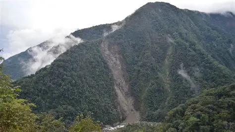
In the mountain village of Kimtang, residents already see troubling signs. Cracks appear in walls and steps. Trees lean at unusual angles. These changes show that the ground beneath the village is slowly shifting.
Scientists now use AI to measure this movement with remarkable accuracy. Antoinette Tordesillas and her team created a system that analyzes satellite radar data. The AI produces color-coded maps that highlight unstable areas. In Kimtang, the system marked a large section in red, signaling a high risk of a landslide.
Although landslides seem sudden, the ground often moves long before collapse occurs. Tiny soil particles shift gradually, almost like a slow, invisible dance. These changes remain impossible to detect with the naked eye, but AI can identify them through detailed satellite imagery.
The technology relies on radar data collected by Sentinel-1. This satellite scans the Earth’s surface and captures precise measurements of terrain movement. It sends thousands of radar signals every second, allowing scientists to monitor even the smallest changes.
Analyzing this massive amount of data manually would take years. AI solves this problem by processing the information quickly and accurately. It uses machine learning models trained on geological patterns to detect early warning signs of slope failure.
This approach combines scientific knowledge with advanced computing. Researchers guide the AI using their understanding of how landslides develop. This makes predictions more reliable and grounded in real-world physics.
The need for such technology continues to grow. Climate change and human activities like construction and mining increase the risk of landslides. In mountainous regions such as Nepal, these disasters occur frequently. In 2025 alone, landslides caused dozens of deaths in the region.
Kimtang’s situation highlights both the danger and the opportunity. Residents were previously relocated after a nearby landslide, only to settle in an even more unstable area. Thanks to AI analysis, experts can now warn the community and prepare safety measures.
Authorities can use this data to design evacuation plans, identify safe zones, and monitor the ground in real time. Early detection gives communities valuable time to act and reduce risk.
AI cannot prevent natural disasters, but it can provide critical insight. By spotting hidden ground movements early, this technology offers a powerful tool to protect lives and property.


