



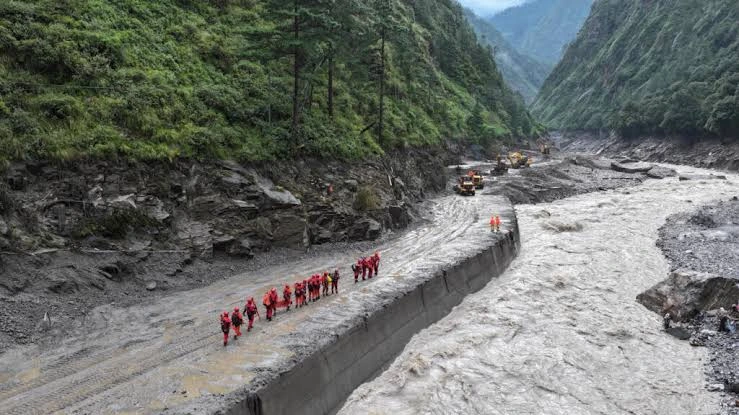
Nepal-China Flood Disaster: Nearly 3,000 Missing After Himalayan Glacier Collapse
The Nepal-China flood disaster has become one of the deadliest Himalayan catastrophes in years, with nearly 3,000 people still missing and at least 676 confirmed dead across Nepal and China’s Tibet region as rescue teams race through mud, collapsed buildings and destroyed river valleys.
The disaster began on the morning of August 26, 2026, when part of a glacier high on Langtang Lirung in Nepal’s Himalayas collapsed.
The enormous mass of ice, rock and debris plunged downhill, entered mountain waterways and rapidly transformed into a destructive debris flow and flash flood.
What followed was devastating.
The Nepal-China flood swept through border communities, buried homes, destroyed bridges and roads, damaged hydropower infrastructure and cut off settlements across Nepal’s Rasuwa, Nuwakot and surrounding districts. Gyirong in Tibet was also badly affected.
By August 29, Nepal had reported at least 669 deaths, while Chinese authorities reported seven deaths in Tibet.
Nearly 3,000 people remained unaccounted for across the two sides of the border, including hundreds of foreign nationals.
Those figures are still changing as rescuers reach communities that were cut off by destroyed roads and thick deposits of mud.
Nepal-China Flood: Key Facts
| Detail | Latest situation |
|---|---|
| Disaster began | August 26, 2026 |
| Primary trigger | Himalayan glacier collapse and debris avalanche |
| Location of collapse | Langtang Lirung area, Nepal |
| Confirmed deaths in Nepal | At least 669 |
| Confirmed deaths in Tibet | At least 7 |
| Missing | Nearly 3,000 across Nepal and Tibet |
| Foreign nationals missing | More than 540 reported in Nepal alone |
| Major affected areas | Rasuwa, Nuwakot, Dhading and Tibet’s Gyirong area |
| Debris/flood travel distance | Approximately 100 km according to USGS analysis |
| Estimated Nepal reconstruction cost | Around $4 billion to $5 billion |
| Continuing danger | Unstable newly formed lakes and damaged mountain terrain |
The casualty and missing-person totals should be treated as provisional.
In disasters of this scale, authorities frequently revise numbers as isolated communities are reached, duplicated missing-person reports are removed and bodies are identified.
What Caused the Nepal-China Flood?
Early reports created some confusion about whether an earthquake caused the catastrophe.
Scientific analysis has since provided a clearer picture.
The U.S. Geological Survey initially detected what appeared to be a seismic event near the Nepal-China border.
Further analysis of long-period seismic waves and satellite imagery showed something very different.
There had not been a conventional magnitude 5.2 earthquake.
Instead, the seismic energy came from an enormous glacial collapse and debris flow.
The collapse originated from a glaciated mountain cliff on the northern side of Langtang Lirung, a peak reaching roughly 7,200 metres.
Part of the glacier and surrounding material broke away and plunged downslope.
The moving mass contained huge quantities of:
- ice;
- rock;
- sediment;
- water;
- and other mountain debris.
As the avalanche descended, ice melted and the moving material collected additional water and debris.
It then entered river channels and evolved into a powerful fast-moving flood.
USGS scientists estimate that the Nepal-China flood and debris flow travelled approximately 100 kilometres, or about 62 miles, downstream.
A second large seismic signal was detected around three hours after the first collapse.
This second event generated energy roughly comparable to a magnitude 4.2 earthquake.
That finding reinforces how enormous the physical processes behind the disaster were.
It Was Not Simply a Glacial Lake Outburst Flood
The Nepal-China flood is sometimes being described online as a glacial lake outburst flood, but the initial trigger appears to have been different.
A classic glacial lake outburst flood occurs when water stored behind ice or unstable sediment suddenly escapes.
In this case, evidence from USGS and regional specialists points to a glacier and rock collapse that transformed into a debris avalanche and flood.
That distinction matters scientifically.
A glacial lake did become important later.
The original collapse rearranged the mountain landscape and created new areas where water could accumulate behind unstable debris.
Those newly formed lakes then became an additional threat to rescue teams and communities downstream.
A New Lake Forced Rescue Operations to Pause
The danger did not end after the initial Nepal-China flood.
The collapse created a new lake high in the disaster zone.
By Friday, concerns that the unstable lake could overflow or suddenly release water became serious enough that authorities temporarily halted some rescue operations.
The fear was straightforward.
If the temporary debris barrier failed suddenly, another surge could travel through valleys where rescuers and survivors were already working.
By August 29, Chinese authorities said the immediate danger had decreased because the lake appeared to be slowly draining naturally.
Satellite measurements indicated that its area had fallen from roughly 120,000 square metres to about 99,000 square metres.
That is encouraging, but the danger has not disappeared.
A second, larger water body is also being monitored, and the mountain slopes remain unstable.
Drones, radar and other monitoring systems are being used to watch for changes.
Nearly 3,000 People Remain Missing
The number of missing people has increased dramatically as local authorities, families and tourism agencies compile more complete lists.
That does not necessarily mean thousands of additional people disappeared after the first day.
It partly reflects the difficulty of determining who was in remote Himalayan communities when the Nepal-China flood struck.
Nepalese authorities have reported thousands missing or unaccounted for, while China says more than 550 people remain missing in Tibet.
More than 540 foreign nationals are among those reported missing in Nepal.
The disaster zone was particularly vulnerable because it included:
- trekking routes;
- pilgrimage areas;
- border workers;
- construction workers;
- hydropower employees;
- tourists;
- transport workers;
- and local Himalayan communities.
People from dozens of countries were believed to be in the wider region.
This has turned the Nepal-China flood into an international search effort as foreign governments try to determine the whereabouts of their citizens.
Hundreds of Foreign Tourists Were in the Disaster Zone
Nepal’s Himalayan regions attract trekkers, climbers and pilgrims from around the world.
The affected border corridor is also strategically important for trade and travel between Nepal and Tibet.
Before casualty lists were fully consolidated, tourism authorities reported hundreds of foreigners unaccounted for.
India had one of the largest groups of affected foreign nationals.
Citizens of the United States, Britain, Australia, Canada, Ukraine, Malaysia, France, South Korea and several other countries were also reported missing or initially unaccounted for.
Some people later appeared on rescue lists.
Others remain missing.
This is one reason the total will probably continue changing.
Rescue Teams Face Extraordinary Conditions
Finding survivors after the Nepal-China flood is extremely difficult.
The flood did not simply fill buildings with clean water.
It carried enormous amounts of:
- mud;
- rock;
- timber;
- ice;
- vehicles;
- structural debris;
- and sediment.
Entire areas are buried.
Roads that normally provide access to mountain settlements have disappeared.
Bridges have been washed away.
Power and telecommunications systems have been damaged.
Helicopters are therefore essential for reaching some communities.
Search teams are also digging through areas where mud is metres deep.
Nepal has requested specialist international assistance for highly technical rescue work, including tunnel operations, victim identification and infrastructure recovery.
India and China are among the countries sending experts and supplies.
International humanitarian assistance is also arriving from other governments and organizations.
More Than 100 People Feared Trapped in Hydropower Infrastructure
One of the most difficult rescue operations involves workers believed to have been trapped around a hydropower facility.
Nepal’s army has deployed specialist equipment, including drilling machinery, in attempts to reach people trapped inside or around project tunnels.
Hydropower is enormously important to Nepal.
The mountainous country uses steep river systems to generate much of its electricity.
Those same locations can become extremely vulnerable during catastrophic debris flows.
The Nepal-China flood damaged multiple hydropower facilities and power infrastructure along the affected river system.
That creates two problems.
First is the immediate danger to workers.
Second is the longer-term threat to Nepal’s electricity supply and economic recovery.
Entire Communities Have Been Buried or Swept Away
Some of the most disturbing reports describe villages where almost nothing recognizable remains.
Survivors have returned to areas covered in thick mud and debris, searching for family members and any belongings that can still be recovered.
Floodwaters travelled downstream through the Bhote Koshi and Trishuli river systems.
The force was powerful enough to:
- destroy houses;
- wash away roads;
- damage bridges;
- bury farmland;
- destroy vehicles;
- damage border facilities;
- and tear through energy infrastructure.
The Nepal-China flood also altered sections of the river landscape itself.
This is not simply a cleanup operation.
Some communities will need to be reconstructed almost from the beginning.
Nepal Says Rebuilding Could Cost $5 Billion
The economic damage is becoming clearer.
Nepal’s government estimates that reconstruction following the Nepal-China flood could cost approximately $4 billion to $5 billion.
For a much larger economy, that would already be a severe disaster.
For Nepal, it represents close to a tenth of annual economic output.
The impact includes:
- destroyed homes;
- damaged roads;
- bridges;
- power stations;
- border infrastructure;
- lost tourism income;
- disrupted trade;
- damaged businesses;
- and future relocation costs.
Hydropower projects affected by the disaster reportedly account for a significant share of Nepal’s electricity-generating capacity.
Nepal’s economy also depends heavily on tourism, remittances and infrastructure that connects difficult Himalayan terrain.
The financial consequences of the Nepal-China flood will therefore continue long after search operations end.
For wider climate-related risks affecting the region, The News Ink has also examined climate change and the possible Super El Niño in 2026. The page is part of the site’s current environmental coverage.
Why the Himalayan Region Is So Vulnerable
The Hindu Kush Himalayan region contains the largest concentration of snow and ice outside the polar regions.
Those glaciers help supply water to river systems serving hundreds of millions of people in mountain regions and more than two billion people downstream.
But the cryosphere is changing rapidly.
The World Meteorological Organization reported that glaciers across Asia are losing mass, with especially serious losses in parts of the central Himalayas.
In its State of the Climate in Asia analysis, 23 of 24 monitored glaciers lost mass.
The International Centre for Integrated Mountain Development has also warned that Himalayan glaciers, snow and permafrost are changing rapidly and that risks including:
- avalanches;
- landslides;
- glacial lake outburst floods;
- debris flows;
- and unstable mountain slopes
are becoming increasingly important.
That regional trend provides essential context for the Nepal-China flood.
Did Climate Change Cause the Nepal-China Flood?
This question needs careful wording.
It is too early to say that climate change directly caused this specific glacier collapse.
Scientists need detailed analysis of:
- temperature;
- ice structure;
- geology;
- precipitation;
- freeze-thaw conditions;
- slope stability;
- and the glacier’s condition before the collapse.
The immediate physical cause is much clearer: a large section of glacier, ice and rock collapsed from Langtang Lirung and produced a rapidly moving debris avalanche and flood.
Climate change may have contributed to conditions making Himalayan slopes and glaciers less stable, but formal attribution of this individual event requires more research.
That distinction matters.
Long-term warming of the Himalayan cryosphere is well established.
The exact cause of one specific collapse is a separate scientific question.
Nepal Has Already Lost Significant Glacier Ice
The Himalayas are undergoing major environmental change.
Research has shown substantial glacier retreat across Nepal and the wider Hindu Kush Himalayan region over recent decades.
Warmer temperatures can affect mountain stability in several ways.
They can:
- increase glacier melt;
- expose steep rock faces;
- degrade permafrost;
- alter snow accumulation;
- create or enlarge glacial lakes;
- and weaken frozen material that helps stabilize slopes.
That does not mean every avalanche or landslide is caused by climate change.
Mountain systems have always experienced natural collapses.
What worries researchers is that warming can change the background conditions in which those hazards occur.
The 2015 Langtang Disaster Offers a Grim Comparison
Langtang has experienced catastrophic ice-and-rock movement before.
During Nepal’s magnitude 7.8 earthquake in April 2015, a massive avalanche descended from the Langtang Lirung area.
Millions of cubic metres of ice, snow and rock fell nearly two kilometres and buried much of Langtang village.
More than 200 people were killed.
The 2026 disaster is different because USGS analysis indicates that the primary seismic signal came from the glacier collapse itself rather than an earthquake.
But the historical comparison demonstrates the extraordinary scale of potential mass movement in the Himalayas.
Why Early Warning Is So Difficult
Flood early-warning systems usually depend on detecting changing water levels and transmitting alerts downstream.
A sudden glacier or rock collapse creates a different challenge.
The Nepal-China flood developed extremely rapidly.
People living downstream had very little time to understand what was happening.
Some survivors described first feeling the ground shake and then seeing an enormous dark wall approaching.
That combination of speed, terrain and limited communications makes Himalayan cascading disasters especially dangerous.
Monitoring cannot focus only on rivers.
Scientists increasingly argue that countries need integrated monitoring of:
- glaciers;
- glacial lakes;
- unstable mountain slopes;
- weather;
- seismic activity;
- and river levels.
Cross-border data sharing is equally important because Himalayan river systems do not stop at national borders.
Why Nepal and China Need Joint Monitoring
The Nepal-China flood demonstrates the practical problem of transboundary hazards.
A collapse in one mountain basin can affect communities across national borders within minutes or hours.
The disaster damaged both Nepal and Tibet.
Information must therefore move faster than the hazard itself.
Better cooperation could include:
- shared satellite monitoring;
- automated water-level sensors;
- glacial-lake monitoring;
- slope-stability assessment;
- rapid-warning protocols;
- emergency communication channels;
- and coordinated evacuation planning.
No monitoring system can stop a glacier from collapsing.
But better detection may give downstream communities precious additional minutes to reach higher ground.
In a flash flood, those minutes can determine survival.
What Happens Next?
The Nepal-China flood has entered two overlapping phases.
Search and Rescue
Authorities are still searching for thousands of people.
This remains the immediate priority.
Identification of Victims
As more bodies are recovered, forensic teams face the difficult task of identification.
DNA samples may be required where visual identification is impossible.
Monitoring Secondary Hazards
New lakes and unstable debris remain under observation.
Heavy rain could create additional landslides or flooding.
Restoring Roads and Electricity
Destroyed transport and energy infrastructure must be repaired to reach isolated communities and restart economic activity.
Temporary Shelter
Thousands of survivors need housing, food, sanitation, healthcare and psychological support.
Reconstruction
The $4 billion to $5 billion estimated cost means reconstruction will likely take years.
Scientific Investigation
Researchers will continue studying exactly why the Langtang Lirung glacier failed and whether changes in climate or local geology increased its instability.
Nepal-China Flood Timeline
| Date | Development |
|---|---|
| Aug. 26 | Glacier and rock mass collapses around Langtang Lirung |
| Minutes later | Debris flow enters river system and devastating flooding begins |
| Aug. 26 | Initial seismic signal mistakenly appears earthquake-like |
| Aug. 26–27 | Flood travels roughly 100 km through populated valleys |
| Aug. 27 | USGS confirms seismic signal came from glacial collapse, not earthquake |
| Aug. 27–28 | Missing and casualty numbers rise sharply |
| Aug. 28 | New lake raises fears of another flood; some rescue work pauses |
| Aug. 29 | Search operations resume as immediate lake risk declines |
| Aug. 29 | Nepal death toll reaches at least 669; nearly 3,000 remain missing across region |
Because rescue work remains active, these figures could change quickly.
Frequently Asked Questions
How many people are missing after the Nepal-China flood?
As of August 29, 2026, authorities reported nearly 3,000 people missing across Nepal and Tibet. The figure remains provisional as rescue teams update lists.
How many people have died?
At least 669 people have been reported dead in Nepal and seven in Tibet, bringing the confirmed regional total to at least 676 as of the latest reports.
What caused the Nepal-China flood?
USGS analysis indicates that a large glacier and rock collapse near Langtang Lirung triggered a debris avalanche that gathered water, sediment and additional material before becoming a catastrophic flash flood.
Was the disaster caused by an earthquake?
No earthquake has been identified as the primary trigger. USGS initially detected what looked like a magnitude 5.2 seismic event but later concluded that the signal itself had been generated by the enormous glacier collapse and debris flow.
Where did the glacier collapse occur?
Scientific analysis places the source on the glaciated slopes of Langtang Lirung in Nepal, close to the Chinese border.
Are more floods possible?
Secondary risk remains. The collapse created new lakes and unstable debris barriers. The immediate danger from one lake had declined by August 29 as it drained, but authorities continue monitoring the region.
Are foreign tourists missing?
Yes. More than 540 foreign nationals were among those reported missing in Nepal, with people from numerous countries affected.
Did climate change cause the glacier collapse?
It is too early to attribute this individual collapse directly to climate change. However, scientists have established that Himalayan glaciers are losing ice rapidly and that warming is increasing several types of high-mountain hazard.
Conclusion
The Nepal-China flood is a disaster still unfolding.
Hundreds of people have died.
Nearly 3,000 remain missing.
Families across Nepal, Tibet and dozens of other countries are waiting for information.
Entire communities have been buried in mud and rock.
Roads, bridges, power infrastructure and homes have disappeared.
Scientific evidence now provides a clearer explanation of what happened.
This was not primarily an earthquake disaster.
A huge section of glacier and mountain material collapsed around Langtang Lirung, generating seismic energy comparable to a magnitude 5.2 earthquake before racing downhill as an ice-and-rock avalanche.
As it entered the river system, the moving mass gathered water, sediment and additional debris, producing a catastrophic flood that travelled roughly 100 kilometres downstream.
The Nepal-China flood also exposes a larger Himalayan vulnerability.
Glaciers, frozen ground, rivers, communities, hydropower systems and cross-border infrastructure exist inside the same rapidly changing mountain environment.
Scientists already know that glaciers across the region are losing mass.
What they do not yet know is exactly how much that long-term warming contributed to this particular collapse.
That question should remain open until evidence is stronger.
The immediate priority is simpler.
Find survivors.
Identify victims.
Protect communities from further flooding.
Restore access to isolated areas.
And begin rebuilding a disaster zone whose recovery Nepal says could cost as much as $5 billion.
The full human toll of the Nepal-China flood may not be known for days or even weeks.
Follow The News Ink
Stay connected with The News Ink for major world news, climate, science, technology and breaking international developments.
Follow The News Ink on X, Instagram and Threads.
Join The News Ink WhatsApp Channel and follow The News Ink on Medium for longer explainers and analysis.