



Indonesia Earthquake: What Happened and Why the Region Is So Vulnerable
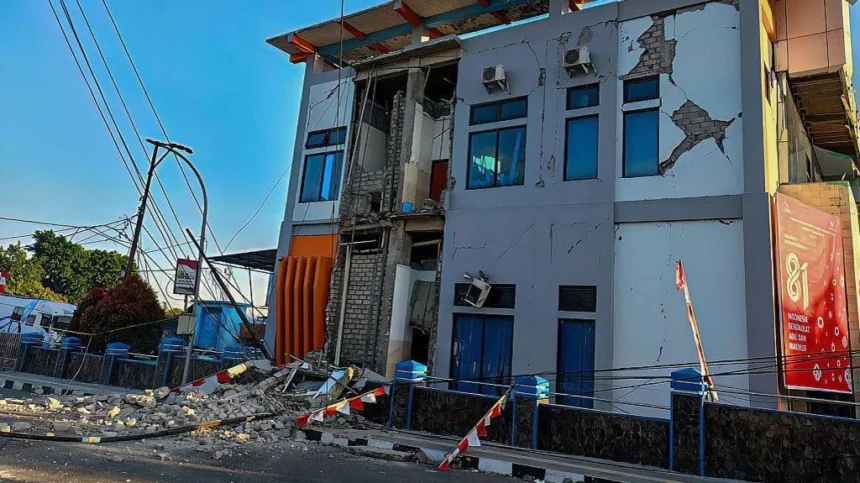
The Indonesia earthquake that struck near Flores early on August 15, 2026, was a magnitude 7.7 event powerful enough to collapse buildings, trigger landslides, cut communications and send thousands of people to higher ground after a tsunami warning. Indonesia’s BMKG placed the epicenter in the sea about 30 kilometers northeast of Mbay in Nagekeo, East Nusa Tenggara, at a shallow depth of 15 kilometers.
By later on August 15, Indonesian officials had reported at least 38 deaths, with rescue teams still struggling to reach some of the hardest-hit areas. Around 2,000 people had evacuated in Nagekeo, while landslides blocked roads and damaged communications complicated efforts to assess the full scale of the disaster. Because casualty and damage figures can change during active rescue operations, those numbers should be treated as an evolving snapshot rather than a final toll.
The Indonesia earthquake also produced a tsunami threat. BMKG issued its first tsunami warning just over two minutes after the Indonesia earthquake. Small tsunami waves, under one meter, were later recorded in several locations, and the warning was lifted after authorities determined that the immediate dangerous sea-level threat had passed.
For people outside the region, the Indonesia earthquake raises an obvious question: why is Indonesia hit by so many destructive earthquakes? The answer lies in its geology. Indonesia sits across one of the most complicated tectonic zones on Earth, where major and smaller plates converge, collide and slide beneath one another. That setting creates extraordinary natural beauty, but it also leaves communities exposed to earthquakes, volcanoes, tsunamis and earthquake-triggered landslides. UNESCO describes the wider Pacific Ring of Fire as one of the world’s most active zones for geological hazards.
Indonesia Earthquake 2026: Key Facts
| Detail | Latest information |
|---|---|
| Date | August 15, 2026 |
| Magnitude | 7.7 |
| Depth | 15 km |
| Epicenter | About 30 km northeast of Mbay, Nagekeo, East Nusa Tenggara |
| Reported deaths | At least 38 as of later August 15 |
| Evacuated in Nagekeo | About 2,000 |
| Tsunami | Waves under 1 meter recorded in several areas |
| Warning status | Tsunami warning lifted |
| Major impacts | Building collapses, landslides, power outages, damaged communications and blocked roads |
The magnitude and location come from BMKG, while the later casualty and evacuation figures were reported by Reuters from Indonesian officials.
These figures explain the immediate scale, but they do not fully explain why the Indonesia earthquake was so dangerous. Magnitude is only one part of earthquake risk. Depth, distance from populated areas, local geology, building quality, terrain, coastal exposure and the timing of the shaking all influence how much damage occurs.
The First Hours After the Quake
The Indonesia earthquake struck at 4:58 a.m. Western Indonesian Time, according to BMKG. That timing increased the danger because many people were asleep when strong shaking began. Reuters reported that at least five people were killed by falling rubble while sleeping, while severe shaking was felt across East Nusa Tenggara, West Nusa Tenggara and parts of South Sulawesi.
BMKG estimated intensity VII on the Modified Mercalli Intensity scale in Aesesa, Riung and Mbay. At that level, people typically rush outdoors and buildings can suffer damage. Intensity VI was estimated in places including Wolowae and Bajawa, while Ende, Borong and Ruteng experienced lower but still widely felt shaking.
The Indonesia earthquake quickly became more than a ground-shaking emergency. Buildings were damaged or collapsed, electricity failed in some locations, landslides blocked roads and communications were disrupted.
Reuters reported that teams had difficulty reaching Nagekeo because road access was obstructed, while another team attempted to approach by ferry. Maumere, the main town in Sikka Regency, was among the locations reporting significant casualties and structural damage.
Indonesia’s disaster agency deployed an emergency response team, logistical support and a helicopter to help reach affected areas. BNPB specifically noted that East Nusa Tenggara’s island geography creates access challenges during emergencies.
The emergency can continue long after the main rupture because damaged buildings remain unstable, roads become impassable and aftershocks can bring down structures already weakened by the first shock.
Why the Magnitude 7.7 Indonesia Earthquake Was So Destructive
Magnitude measures the energy released by an earthquake, but it does not directly tell us how much damage people on the ground will experience.
The Indonesia earthquake was particularly concerning because it was shallow. BMKG measured the depth at 15 kilometers. In general, shallow earthquakes can produce intense surface shaking close to the source because seismic energy travels a shorter distance before reaching nearby communities.
Location mattered too. The epicenter was offshore but close to Flores and nearby communities. That combination created two hazards at once: strong shaking on land and the possibility that movement beneath the sea could displace enough water to generate a tsunami.
Construction also matters. Engineered buildings designed for seismic forces can perform very differently from unreinforced masonry or poorly connected structures. The Indonesia earthquake therefore shows why similar magnitudes can produce very different outcomes: depth, proximity, geology and building quality all shape the damage.
This is useful context when comparing the disaster with other recent earthquakes covered by The News Ink. A Hawaii earthquake and the Redlands earthquake occurred in very different geological and built environments, so magnitude alone should never be treated as a simple measure of expected destruction.
Indonesia Sits in a Collision Zone of Tectonic Plates
The main reason the region is vulnerable is plate tectonics.
Earth’s outer shell is divided into tectonic plates that move slowly over geological time. Where plates meet, they can pull apart, slide sideways or collide. Indonesia lies across a broad zone where several of those interactions occur.
Along much of western and southern Indonesia, the Australian Plate moves toward and beneath the Sunda Plate. This process, known as subduction, stores enormous stress along faults. When a locked section suddenly slips, stored energy is released as an earthquake.
The U.S. Geological Survey describes the Australia-Sunda plate boundary as highly seismically active. In one well-studied part of the boundary, the Australian Plate moves toward the Sunda Plate at roughly 59 millimeters per year.
That may sound slow, but tectonic strain accumulates over years, decades and centuries.
Eastern Indonesia is even more complicated. Flores, Timor, the Banda Sea and surrounding islands sit in a region where several tectonic blocks and plate-boundary systems interact. The result is a landscape crossed by active faults and subduction systems rather than one simple boundary.
That is why the phrase “Ring of Fire” is useful but incomplete. Indonesia is indeed part of the Pacific Ring of Fire, a zone known for frequent earthquakes and volcanic activity. Yet the country’s seismic danger comes from specific local plate interactions and faults, not from one circular fault running around the Pacific.
The Indonesia earthquake is therefore part of a much larger geological system that has been active for millions of years and will continue producing earthquakes.
Why the Tsunami Warning Was Necessary
An offshore magnitude 7.7 earthquake immediately raises concern about a tsunami.
Tsunamis are not simply giant wind-driven waves. They form when a large volume of water is displaced suddenly. Large, shallow earthquakes beneath or near the ocean are among the most common causes, particularly when fault movement lifts or lowers the seafloor.
NOAA explains that most earthquake-generated tsunamis are associated with large events near the ocean floor, particularly around subduction zones. Not every strong offshore earthquake produces a destructive tsunami because the type, direction and amount of seafloor movement matter.
In the Indonesia earthquake, BMKG modeling indicated tsunami potential and issued warnings for parts of East Nusa Tenggara, West Nusa Tenggara and South Sulawesi.
Some areas initially received “Siaga” status, associated with modeled wave heights between 0.5 and 3 meters, while others received lower “Waspada” alerts.
The agency said its first warning was distributed two minutes and 16 seconds after the earthquake. That speed matters because a locally generated tsunami can reach nearby shores quickly.
Observed waves remained below one meter in locations reported by Reuters, and the tsunami warning was later lifted. A relatively small observed wave does not mean the warning was unnecessary. Warning systems must act before complete observations are available because waiting for certainty can cost lives when the source is close to shore.
The Indonesia Tsunami Early Warning System and community evacuation planning are therefore critical parts of the country’s defenses.
UNESCO’s Tsunami Ready program has also recognized Indonesian communities that maintain hazard maps, evacuation plans, warning systems and regular exercises.
Flores Has Lived Through This Before
The Indonesia earthquake struck a region with painful historical experience.
In December 1992, a major earthquake and tsunami devastated Flores. Reuters, citing BMKG, noted that the same broad area was hit by a magnitude 7.5 earthquake in 1992 that caused extensive destruction.
The lesson is not that history repeats exactly, but that seismic and tsunami risk on Flores is well established.
Indonesia’s disaster memory is also shaped by the 2004 Indian Ocean earthquake and tsunami. UNESCO describes that event as the deadliest tsunami in recorded history and says more than 160,000 people died from the earthquake and tsunami in Indonesia alone.
In 2018, the Sulawesi earthquake and tsunami again demonstrated how cascading hazards can multiply losses through shaking, tsunami inundation and severe ground failure.
Those disasters drove improvements in warning and preparedness, while also showing how difficult it is to manage risk across thousands of islands, long coastlines and mountainous terrain. UN disaster-risk experts continue to identify Indonesia as highly exposed to earthquakes, tsunamis, volcanic eruptions and other natural hazards.
Landslides Turn Shaking Into a Second Disaster
The Indonesia earthquake also triggered landslides that blocked roads, illustrating another reason eastern Indonesia can be difficult to protect.
Strong shaking can destabilize steep slopes, especially where rock or soil is already fractured or weathered. Once a slope fails, the consequences can include buried roads, isolated villages, damaged bridges and secondary casualties.
After the Indonesia earthquake, landslides reportedly prevented rescue teams from reaching parts of the affected region by road. That means the hazard did more than damage homes. It slowed the response itself.
The geography of Flores amplifies this problem. Much of the island is mountainous and volcanic. Roads often wind through steep terrain, so a relatively small number of slope failures can cut communities off from hospitals, heavy equipment and emergency supplies.
This is where newer monitoring technologies may eventually help. The News Ink has examined how AI can detect ground movement associated with some landslide risks. Such systems cannot predict earthquakes, but better slope monitoring, satellite analysis and rapid mapping can help authorities identify unstable terrain and prioritize response routes after major shaking.
Why Buildings Decide Who Survives
Geology creates the hazard, but buildings often determine the human toll.
Earthquakes do not usually kill people simply because the ground moves. Many casualties come from collapsing walls, roofs, concrete, glass and other structural failures. Reuters reported fatalities from falling rubble after the Indonesia earthquake, reinforcing the importance of construction quality.
Indonesia has made progress on disaster-resilient construction, but enforcing standards across a vast archipelago is difficult. Rural homes may use locally available materials, older buildings may predate modern standards, and informal construction may lack reinforcement.
Design rules matter only when materials, workmanship, inspection and maintenance also perform.
The World Bank has supported Indonesia’s efforts to strengthen disaster preparedness and resilience, including measures aimed at reducing vulnerability to multiple natural hazards.
For earthquake-prone communities, resilience includes stronger schools and hospitals, safer housing, protected lifeline infrastructure and land-use planning that considers faults, unstable slopes and tsunami zones.
A resilient hospital is particularly important. After the Indonesia earthquake, footage cited by Reuters showed patients being moved outdoors at a hospital in Ende. Medical facilities need to remain usable precisely when demand suddenly increases.
An Archipelago Makes Emergency Response Harder
Indonesia’s geography creates another vulnerability that has nothing to do with the strength of the earthquake itself.
The country is an enormous archipelago. Communities are separated by sea, mountains and limited road networks. In a major urban center, rescue teams may have several routes into a disaster zone. On an island with damaged roads, landslides and disrupted communications, there may be few alternatives.
That was visible after the Indonesia earthquake. Rescue teams trying to reach Nagekeo encountered landslide-blocked roads and communication problems. A ferry route was considered because ground access was impaired, while BNPB also prepared helicopter support.
This logistical challenge affects search and rescue, medical transport, restoration of power and communications, delivery of emergency supplies and the basic task of assessing isolated villages.
It also explains why early casualty figures can change. Authorities may have good information from accessible towns while knowing far less about remote communities closer to the epicenter.
For that reason, the death toll after the Indonesia earthquake may continue to be revised as rescue and assessment teams reach additional locations.
Early Warning Helps, but It Cannot Remove the Risk
Indonesia has invested heavily in disaster preparedness after the catastrophic events of recent decades.
BMKG operates seismic monitoring and the national tsunami early-warning system. In the latest Indonesia earthquake, the first tsunami alert was issued within minutes.
But an alert is only one link in a much longer chain.
A warning saves lives only if it reaches people, is understood and can be acted upon quickly. Coastal residents need usable evacuation routes, accessible higher ground or vertical evacuation options, and plans that work for schools, workplaces, older residents, people with disabilities and visitors.
UNESCO’s Tsunami Ready program focuses on this community-level preparation, including maps, signs, drills, emergency plans and public education. Indonesian communities participating in the program demonstrate how technical warnings and local readiness have to work together.
The 2018 Palu disaster also highlighted the gap between detecting a hazard and producing effective community action. Technology cannot compensate for every communications failure, damaged road or evacuation bottleneck. UNDRR has specifically examined those limitations in Indonesia’s early-warning chain.
What Residents Should Watch After a Major Earthquake
The immediate tsunami warning from the Indonesia earthquake has been lifted, but other hazards can persist.
After the Indonesia earthquake, aftershocks may damage structures weakened by the main shock, while unstable slopes, damaged utilities and compromised bridges can create new dangers.
BMKG advised residents to avoid cracked or damaged buildings and rely on official information. General earthquake safety guidance also advises people to expect aftershocks and avoid damaged structures.
Practical precautions include following local instructions, staying away from restricted coastal areas, expecting aftershocks, watching unstable slopes and avoiding unverified rumors. Local emergency guidance should always take priority because conditions differ from one district to another.
The Real Meaning of Indonesia’s Vulnerability
Calling Indonesia “earthquake-prone” can make disaster losses sound inevitable. They are not.
Tectonic hazards cannot be prevented, but vulnerability can be reduced.
Risk reflects the combination of hazard, exposure and vulnerability. The Indonesia earthquake was the hazard; people and infrastructure created exposure; weak buildings, difficult access and communication failures can increase vulnerability.
Governments and communities cannot stop plate movement, but they can reduce the consequences.
The most effective measures are often practical rather than dramatic:
- stronger earthquake-resistant construction;
- safer schools and hospitals;
- reliable backup communications;
- multiple emergency transport routes;
- clear coastal evacuation plans;
- frequent public drills;
- accurate hazard maps;
- and rapid access to trusted warnings.
The Indonesia earthquake demonstrates both sides of that equation. The tectonic setting made a magnitude 7.7 event possible, but the eventual human cost is also shaped by where people lived, how buildings performed, whether routes remained open and how quickly help could reach isolated communities.
That distinction is important because describing Indonesia’s disasters as simply unavoidable can hide the value of prevention. International disaster-risk agencies emphasize that exposure and vulnerability can be lowered even when the underlying natural hazard remains.
Frequently Asked Questions
How strong was the Indonesia earthquake?
BMKG measured the August 15, 2026 Indonesia earthquake at magnitude 7.7 with a depth of 15 kilometers. Its epicenter was offshore about 30 kilometers northeast of Mbay in Nagekeo, East Nusa Tenggara.
How many people died?
Indonesian officials reported at least 38 deaths by later August 15, according to Reuters. Rescue and damage assessments were continuing, so the total may be revised.
Did the earthquake cause a tsunami?
The Indonesia earthquake triggered a tsunami warning, and waves below one meter were observed in several areas. BMKG later declared the immediate tsunami threat over and lifted the warning.
Why does Indonesia have so many earthquakes?
Indonesia lies across highly active tectonic boundaries where major plates and smaller crustal blocks interact. Subduction and faulting repeatedly release accumulated stress as earthquakes.
Can scientists predict the next Indonesian earthquake?
Scientists can identify active faults, map seismic hazards and estimate probabilities, but there is no reliable method for predicting the exact time, location and magnitude of a future earthquake. Preparedness, resilient construction and rapid warning systems therefore remain essential.
Conclusion
The Indonesia earthquake of August 15, 2026, was a powerful reminder that natural hazards in the archipelago rarely occur in isolation.
The magnitude 7.7 Indonesia earthquake caused severe shaking, building collapses and landslides, disrupted roads and communications, and created enough tsunami risk for authorities to order urgent coastal precautions.
At least 38 people had been reported dead by later in the day, and that number could change as teams reach areas that were initially difficult to access. The tsunami warning has been lifted, but aftershocks, damaged structures and unstable slopes remain concerns.
The deeper reason for Indonesia’s vulnerability is geological. The country sits where tectonic plates and smaller crustal blocks converge, producing frequent earthquakes and volcanic activity. Its long coastline creates tsunami exposure, while steep terrain can turn shaking into landslides. An enormous island geography then makes emergency response harder when roads, power and communications fail.
Yet the Indonesia earthquake also shows why preparedness matters. BMKG issued a tsunami warning within minutes, communities evacuated, and Indonesia has expanded monitoring, warning and disaster education after earlier catastrophes. Those systems cannot stop earthquakes, but they can reduce the number of lives lost.
The long-term lesson is not that Indonesia is helpless against its geology. It is that resilience has to be built continuously through safer construction, stronger infrastructure, faster warnings, realistic evacuation plans and public understanding of what to do when the ground starts moving.
Follow The News Ink
Stay connected with The News Ink for coverage of world news, science, technology, health and sports.
Follow us on X, Instagram, Threads, TikTok, Bluesky and Mastodon.
For longer-form coverage and discussion, follow The News Ink on Medium, Substack and Quora, or discover visual stories on Pinterest.